• Home
  • Search
  • Browse Collections
  • My Account
  • About
  • DC Network Digital Commons Network™
Skip to main content
Digital Commons @ University of South Florida
  • USF Home
  • USF Research
  • USF Libraries

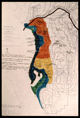
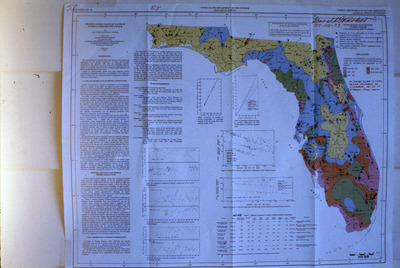
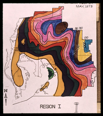
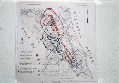
Digital Commons @ USF > USF Libraries > USF Digital Collections > Tampa Digital Collections > Tampa Special Collections > Environment and Natural History > Dr. Garald Gordon Parker Collection > Maps

Dr. Garald Gordon Parker Collection

Dr. Garald Gordon Parker - Maps

 
Selected maps from the Dr. Garald Gordon Parker collection.
Printing is not supported at the primary Gallery Thumbnail page. Please first navigate to a specific Image before printing.

Follow

Switch View to List View Slideshow
 
  • Map, Putnam Hall High, A by Garald Gordon Parker

    Map, Putnam Hall High, A

  • Map, Putnam Hall High, B by Garald Gordon Parker

    Map, Putnam Hall High, B

  • Map, Rainbow Springs by Garald Gordon Parker

    Map, Rainbow Springs

  • Maps and Technical Drawings, Lake County by Garald Gordon Parker

    Maps and Technical Drawings, Lake County

  • Maps, Chloride Concentrations in Groundwater at Different Depths in the Everglades by Garald Gordon Parker

    Maps, Chloride Concentrations in Groundwater at Different Depths in the Everglades

  • Map, Soil Association Map for Hillsborough County, Florida by Garald Gordon Parker

    Map, Soil Association Map for Hillsborough County, Florida

  • Map, Southwest Florida Water Management District by Garald Gordon Parker

    Map, Southwest Florida Water Management District

  • Map, Southwest Florida Water Management District Boundaries by Garald Gordon Parker

    Map, Southwest Florida Water Management District Boundaries

  • Map, Southwest Florida Water Management District Project Boundaries by Garald Gordon Parker

    Map, Southwest Florida Water Management District Project Boundaries

  • Map, Southwest Florida Water Management District Proposed Pipeline by Garald Gordon Parker

    Map, Southwest Florida Water Management District Proposed Pipeline

  • Map, Story Mine Project Area by Garald Gordon Parker

    Map, Story Mine Project Area

  • Map, Strip Mine Locations near Durant, Florida, A by Garald Gordon Parker

    Map, Strip Mine Locations near Durant, Florida, A

  • Map, Strip Mine Locations near Durant, Florida, B by Garald Gordon Parker

    Map, Strip Mine Locations near Durant, Florida, B

  • Map, Surface-Water Drainage Features of Green Swamp Area by Garald Gordon Parker

    Map, Surface-Water Drainage Features of Green Swamp Area

  • Map, Top of Artesian Floridan Aquifer by Garald Gordon Parker

    Map, Top of Artesian Floridan Aquifer

  • Map, Top of Distal End of Artesian Aquifer by Garald Gordon Parker

    Map, Top of Distal End of Artesian Aquifer

  • Map, Topography of Central Florida and Its Relation to the Green Swamp Area by Garald Gordon Parker

    Map, Topography of Central Florida and Its Relation to the Green Swamp Area

  • Map, U.S. Geological Survey Map of the Floridan Aquifer by Garald Gordon Parker

    Map, U.S. Geological Survey Map of the Floridan Aquifer

  • Partial Map of Hillsborough County by Garald Gordon Parker

    Partial Map of Hillsborough County

  • Map, Average Annual Lake Evaporation by United States Geological Survey

    Map, Average Annual Lake Evaporation

  • Map, Florida Showing the Areas in Northern and Central Florida in which Groundwater Supplies are Contaminated with Salty Water by U.S. Geological Survey

    Map, Florida Showing the Areas in Northern and Central Florida in which Groundwater Supplies are Contaminated with Salty Water

  • Map, Average Flow of Major Streams in Florida by Garald Gordon Parker

    Map, Average Flow of Major Streams in Florida

  • Map, Drainage Basins and Discharge of Surface Water from the State of Florida to the Atlantic and to the Gulf by Garald Gordon Parker

    Map, Drainage Basins and Discharge of Surface Water from the State of Florida to the Atlantic and to the Gulf

  • Map, Geologic Map of West-Central Florida, July 1969 by Garald Gordon Parker

    Map, Geologic Map of West-Central Florida, July 1969

  • Map, Geologic Map of West-Central Florida, May 1969 by Garald Gordon Parker

    Map, Geologic Map of West-Central Florida, May 1969

  • Map, Principal Aquifers of Florida by Garald Gordon Parker

    Map, Principal Aquifers of Florida

  • Maps, Major Streams in Florida by Garald Gordon Parker

    Maps, Major Streams in Florida

  • Map, Chloride Content of Water from the Floridan Aquifer, Lake County, 1968 by Garald Gordon Parker

    Map, Chloride Content of Water from the Floridan Aquifer, Lake County, 1968

  • Map, Depth to Water and Potentiometric Surface of the Floridan Aquifer, Lake County, May 1968 by Garald Gordon Parker

    Map, Depth to Water and Potentiometric Surface of the Floridan Aquifer, Lake County, May 1968

  • Map, Dissolved Solids of Water from the Floridan Aquifer, Lake County, 1968 by Garald Gordon Parker

    Map, Dissolved Solids of Water from the Floridan Aquifer, Lake County, 1968

  • Map, St. Johns River Basin by Garald Gordon Parker

    Map, St. Johns River Basin

  • Map, Piezometric Surface of Water in the Principal Artesian Aquifer, 1961 by Garald Gordon Parker

    Map, Piezometric Surface of Water in the Principal Artesian Aquifer, 1961

  • Map, Waccasassa River, Florida by Garald Gordon Parker

    Map, Waccasassa River, Florida

  • Map, Piezometric Surface, Areas of Artesian Flow and Centers of Pumpage in the Floridan Aquifer, January 1964 by United States Geological Survey

    Map, Piezometric Surface, Areas of Artesian Flow and Centers of Pumpage in the Floridan Aquifer, January 1964

  • Map, Piezometric Surface of Artesian Water by Garald Gordon Parker

    Map, Piezometric Surface of Artesian Water

  • Map, Contours on the Potentiometric Surface of the Floridan Aquifer, 1961 by Garald Gordon Parker

    Map, Contours on the Potentiometric Surface of the Floridan Aquifer, 1961

  • Map, Decline in Potentiometric Surface of the Floridan Aquifer, November 1959 to May 1962 by Garald Gordon Parker

    Map, Decline in Potentiometric Surface of the Floridan Aquifer, November 1959 to May 1962

  • Map, Green Swamp Area Showing Contours of the Potentiometric Surface of the Floridan Aquifer during a Wet Period, November 1959 by Garald Gordon Parker

    Map, Green Swamp Area Showing Contours of the Potentiometric Surface of the Floridan Aquifer during a Wet Period, November 1959

  • Map, Green Swamp Area Showing Depths to the Top of the Floridan Aquifer by Garald Gordon Parker

    Map, Green Swamp Area Showing Depths to the Top of the Floridan Aquifer

  • Map, Potentiometric Surface, Floridan Aquifer by Garald Gordon Parker

    Map, Potentiometric Surface, Floridan Aquifer

  • Map and Bar Graphs, Nature Frequently Furnishes Water when Needed by Garald Gordon Parker

    Map and Bar Graphs, Nature Frequently Furnishes Water when Needed

  • Map, Potentiometric Surface of Floridan Aquifer for September 1949, Focused on Citrus County by Garald Gordon Parker

    Map, Potentiometric Surface of Floridan Aquifer for September 1949, Focused on Citrus County

  • Maps, Some Water-Quality Problems are Natural by Garald Gordon Parker

    Maps, Some Water-Quality Problems are Natural

  • Maps, Some Water-Quality Problems Result from Man's Actions by Garald Gordon Parker

    Maps, Some Water-Quality Problems Result from Man's Actions

  • Map, Water Worth Varies Seasonally by Garald Gordon Parker

    Map, Water Worth Varies Seasonally

  • Map, Tectonic Map of the United States, Gulf Coast States by Garald Gordon Parker

    Map, Tectonic Map of the United States, Gulf Coast States

  • Map, Tectonic Map of the United States, Southeast by Garald Gordon Parker

    Map, Tectonic Map of the United States, Southeast

 
  • 1
  • 2


Search

Advanced Search

  • Email Notifications and RSS

Browse By

  • All Collections
  • Author
  • USF Faculty Publications
  • Open Access Journals
  • Conferences and Events
  • Theses and Dissertations
  • Textbooks Collection

Useful Links

  • My Account
  • Rights Information
  • SelectedWorks
  • Submit Research

Gallery Locations

  • View gallery on map
  • View gallery in Google Earth
 
Elsevier - Digital Commons

Home | About | Help | My Account | Accessibility Statement

Privacy Copyright

USF Libraries