

Dr. Garald Gordon Parker Collection - Images
Files
Download Full Text (5.4 MB)
Preview
Creation Date
1-18-1966
Abstract
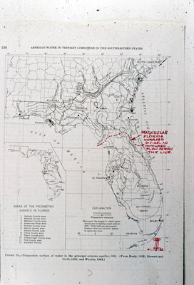
Map showing piezometric surface of water in the principal artesian aquifer, 1961. Also marked on the map is a line indicating the Peninsular Florida Hydrologic Divide.
Alt Text
A map of the southeastern United States highlighting artesian water boundaries, with annotations and labels indicating specific regions and features. The map includes detailed lines marking different geological and hydrological areas.
Keywords
Piezometer, Artesian wells, Artesian basins, Hydrogeology
Extent
1 map
Physical Collection
Language
English
Media Type
Maps
Identifier
G16-00149
Recommended Citation
Parker, Garald Gordon, "Map, Piezometric Surface of Water in the Principal Artesian Aquifer, 1961" (1966). Dr. Garald Gordon Parker Collection - Images. Image 110.
https://digitalcommons.usf.edu/parker_photographs/110
Keywords
Piezometer, Artesian wells, Artesian basins, Hydrogeology
Rights Statement

