

Dr. Garald Gordon Parker Collection - Images
Files
Download
Download Full Text (2.7 MB)
Preview
Creation Date
1950
Time Period
circa 1950s
Abstract
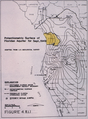
Map showing the potentiometric surface of the Floridan Aquifer in West-Central Florida for September 1949.
Alt Text
A map of Florida highlighting the potentiometric surface of the Floridan Aquifer as of September 1949, with various contour lines and labeled regions. The map includes an explanation of symbols used and a scale for distance measurement.
Keywords
Floridan Aquifer, Aquifers, Potentiometry
Extent
1 map
Physical Collection
Language
English
Media Type
Maps
Identifier
G16-00595
Recommended Citation
Parker, Garald Gordon, "Map, Potentiometric Surface of Floridan Aquifer for September 1949, Focused on Citrus County" (1950). Dr. Garald Gordon Parker Collection - Images. Image 513.
https://digitalcommons.usf.edu/parker_photographs/513
Keywords
Floridan Aquifer, Aquifers, Potentiometry
Rights Statement

