

Dr. Garald Gordon Parker Collection - Images
Files
Download
Download Full Text (4.3 MB)
Preview
Creation Date
1970
Time Period
circa 1970-1987
Abstract
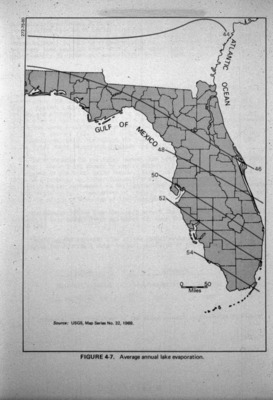
Map of Florida showing average annual lake evaporation.
Alt Text
A map of Florida with labeled regions indicating average annual lake evaporation rates, ranging from 48 to 63 inches. The Gulf of Mexico and the Atlantic Ocean are marked on the sides.
Keywords
Lakes, Evaporation
Extent
1 map
Physical Collection
Language
English
Media Type
Maps
Identifier
G16-00056
Recommended Citation
United States Geological Survey, "Map, Average Annual Lake Evaporation" (1970). Dr. Garald Gordon Parker Collection - Images. Image 18.
https://digitalcommons.usf.edu/parker_photographs/18
Keywords
Lakes, Evaporation
Rights Statement

