

Dr. Garald Gordon Parker Collection - Images
Files
Download
Download Full Text (4.8 MB)
Preview
Creation Date
5-1968
Time Period
circa May 1968
Abstract
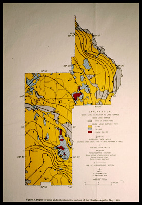
Map showing depth to water and potentiometric surface of the Floridan Aquifer for May 1968.
Alt Text
A detailed map with color-coded sections and various annotations, showing the depth to water and potentiometric surface of the Floridan Aquifer in Lake County, Florida, as of May 1968. The map includes an explanation key and several labeled features.
Keywords
Floridan Aquifer, Aquifers, Potentiometry
Extent
1 map
Subject: geographic
Lake County (Fla.)
Physical Collection
Language
English
Media Type
Maps
Identifier
G16-00512
Recommended Citation
Parker, Garald Gordon, "Map, Depth to Water and Potentiometric Surface of the Floridan Aquifer, Lake County, May 1968" (1968). Dr. Garald Gordon Parker Collection - Images. Image 480.
https://digitalcommons.usf.edu/parker_photographs/480
Keywords
Floridan Aquifer, Aquifers, Potentiometry
Rights Statement

