
Binder 02: Field Notes and Documents
Files
Download Full Text (4.5 MB)
Publication Date
9-1989
Abstract
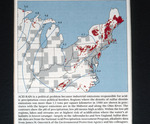
A map showing regions with sulfur dioxide emissions greater than 1.5 tons per square kilometer in 1980, focusing on the Midwest and areas along the Ohio River. Contours on the map indicate pH levels, where lower values represent higher acidity. The map highlights areas most affected by acid rain and the potential environmental impacts, particularly in regions like the Adirondacks and New England.
Keywords
Acid rain, Weather, Precipitation, Sulfur dioxide
Extent
1 map
Physical Collection
Box
1
Folder
Binder 2
Language
English
Digital Date
2024
Media Type
Maps
Identifier
O19-02172
Recommended Citation
Scientific American, "Map, Acid Rain Sulfur Dioxide Emissions and pH Levels in the Northeastern United States, September 1989" (1989). Binder 02: Field Notes and Documents. 52.
https://digitalcommons.usf.edu/ogden2_notes/52
Rights Statement

