
Binder 02: Field Notes and Documents
Files
Download
Download Full Text (4.7 MB)
Publication Date
9-1989
Abstract
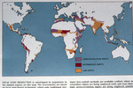
A map illustrating global patterns of agricultural input usage and areas where local food production is outstripped by population. The map uses color coding to represent regions that employ different levels of agricultural inputs: green-revolution inputs (green), intermediate inputs (red), and low inputs (yellow).
Keywords
Energy, Resources, Food, Agriculture
Extent
1 map
Physical Collection
Box
1
Folder
Binder 2
Language
English
Digital Date
2024
Media Type
Maps
Identifier
O19-02177
Recommended Citation
Scientific American, "Map, Local Food Production and Agricultural Inputs, September 1989" (1989). Binder 02: Field Notes and Documents. 55.
https://digitalcommons.usf.edu/ogden2_notes/55
Rights Statement

