

Dr. Garald Gordon Parker Collection - Images
Files
Download Full Text (15.2 MB)
Preview
Creation Date
9-1977
Abstract
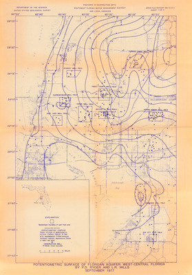
A map of the potentiometric surface of the Floridan Aquifer in west-central Florida. Legend includes generalized boundary of well field area, potentiometric contour [Shows altitude of potentiometric surface. Contour interval 10 feet with supplemental 5-foot contours. Hachures indicate depressions. Datum is mean sea level], and observation.
Alt Text
A detailed map with blue lines and various annotations, depicting the potentiometric surface of a region in west-central Florida. The map includes labels, grid lines, and an explanation key at the bottom left corner.
Keywords
Floridan Aquifer, Aquifers, Potentiometry
Extent
1 map
Physical Collection
Box
10
Folder
8
Language
English
Media Type
Maps
Identifier
G16-00013
Recommended Citation
Ryder, P. D. and Mills, L. R., "Map, Potentiometric Surface of Floridan Aquifer, West-Central Florida" (1977). Dr. Garald Gordon Parker Collection - Images. Image 463.
https://digitalcommons.usf.edu/parker_photographs/463
Keywords
Floridan Aquifer, Aquifers, Potentiometry
Rights Statement

