

Dr. Garald Gordon Parker Collection - Images
Files
Download Full Text (7.3 MB)
Preview
Creation Date
9-28-1977
Abstract
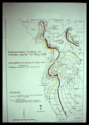
Map showing potentiometric surface of Floridan Aquifer for May 1965 focusing on West-Central Florida. Also on the map are the boundaries of the Southwest Florida Water Management District.
Alt Text
A map showing the potentiometric surface of the Floridan Aquifer for May 1965, with various contour lines and regions labeled. The map includes an explanation section at the bottom left corner.
Keywords
Floridan Aquifer, Aquifers, Potentiometry, Southwest Florida Water Management District (Fla.)
Extent
1 map
Physical Collection
Language
English
Media Type
Maps
Identifier
G16-00452
Recommended Citation
Parker, Garald Gordon, "Map, Potentiometric Surface of Floridan Aquifer for May 1965" (1977). Dr. Garald Gordon Parker Collection - Images. Image 412.
https://digitalcommons.usf.edu/parker_photographs/412
Keywords
Floridan Aquifer, Aquifers, Potentiometry, Southwest Florida Water Management District (Fla.)
Rights Statement

