

Dr. Garald Gordon Parker Collection - Images
Files
Download Full Text (16.5 MB)
Preview
Creation Date
9-1977
Abstract
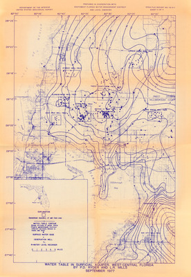
A map of the water table in surficial aquifer of West-Central Florida. Legend includes generalized boundary of well field area, water-table contour [shows altitude of water table (highly generalized). Contour interval variable. Datum is mean sea level], surface-water gage, observation well, and R=water=level recorder.
Alt Text
A detailed map showing water table levels and geological features Tampa Bay, Florida. The map includes contour lines, labels, and various annotations.
Keywords
Water levels, Water table, Aquifers
Extent
1 map
Physical Collection
Box
10
Folder
8
Language
English
Media Type
Maps
Identifier
G16-00015
Recommended Citation
Ryder, P. D. and Mills, L. R., "Map, Water Table in Surficial Aquifer, West-Central Florida" (1977). Dr. Garald Gordon Parker Collection - Images. Image 465.
https://digitalcommons.usf.edu/parker_photographs/465
Keywords
Water levels, Water table, Aquifers
Rights Statement

