

Dr. Garald Gordon Parker Collection - Images
Files
Download Full Text (10.0 MB)
Preview
Creation Date
9-30-1977
Abstract
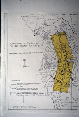
Map showing potentiometric surface of Floridan Aquifer for May 1970 focused on West-Central Florida. Also on the map are the boundaries of the Southwest Florida Water Management District and the peninsular Florida hydrologic divide.
Alt Text
Map showing potentiometric surface of Floridan Aquifer for May 1970 focused on West-Central Florida. Also on the map are the boundaries of the Southwest Florida Water Management District and the peninsular Florida hydrologic divide.
Keywords
Floridan Aquifer, Aquifers, Potentiometry, Southwest Florida Water Management District (Fla.)
Extent
1 map
Physical Collection
Language
English
Media Type
Maps
Identifier
G16-00359
Recommended Citation
Parker, Garald Gordon, "Map, Potentiometric Surface of Floridan Aquifer for May 1970" (1977). Dr. Garald Gordon Parker Collection - Images. Image 320.
https://digitalcommons.usf.edu/parker_photographs/320
Keywords
Floridan Aquifer, Aquifers, Potentiometry, Southwest Florida Water Management District (Fla.)
Rights Statement

