

Dr. Garald Gordon Parker Collection - Images
Files
Download Full Text (4.4 MB)
Preview
Creation Date
9-30-1977
Abstract
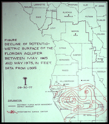
Map showing decline of the potentiometric surface of the Floridan Aquifer between May 1965 and May 1975 focused on West-Central Florida.
Alt Text
A map showing the decline of the potentiometric surface of the Floridan Aquifer between May 1965 and May 1975, with contour lines indicating changes in feet. The map includes county boundaries and labels for various locations in Florida.
Keywords
Floridan Aquifer, Aquifers, Potentiometry
Extent
1 map
Physical Collection
Language
English
Media Type
Maps
Identifier
G16-00454
Recommended Citation
Parker, Garald Gordon, "Map, Decline of Potentiometric Surface of Floridan Aquifer between May 1965 and May 1975 in Feet" (1977). Dr. Garald Gordon Parker Collection - Images. Image 414.
https://digitalcommons.usf.edu/parker_photographs/414
Keywords
Floridan Aquifer, Aquifers, Potentiometry
Rights Statement

