

Dr. Garald Gordon Parker Collection - Images
Files
Download
Download Full Text (10.1 MB)
Preview
Creation Date
1970
Time Period
circa 1970-1987
Abstract
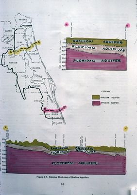
Map and diagram showing depth of geologic layers of Florida from Alachua County south to Indian River County.
Alt Text
A map of Florida highlighting different aquifer regions with a cross-sectional diagram showing the layers of shallow and Floridan aquifers. The legend indicates the color coding for these aquifers.
Keywords
Floridan Aquifer, Aquifers, Geology, Geologic cross sections, Hydrogeology
Extent
1 map and 2 diagrams
Physical Collection
Language
English
Media Type
Maps; Diagrams
Identifier
G16-00158
Recommended Citation
Parker, Garald Gordon, "Diagram and Map, Relative Thickness of Shallow Aquifers" (1970). Dr. Garald Gordon Parker Collection - Images. Image 119.
https://digitalcommons.usf.edu/parker_photographs/119
Keywords
Floridan Aquifer, Aquifers, Geology, Geologic cross sections, Hydrogeology
Rights Statement

