
Binder 02: Field Notes and Documents
Files
Download
Download Full Text (3.5 MB)
Publication Date
1-1-1980
Abstract
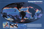
A map showcasing global ocean color as observed from space. The image depicts oceanic distributions of phytoplankton, as measured by NASA's Coastal Zone Color Scanner (CZCS).
Keywords
Oceanography, Marine science, Remote sensing
Extent
1 map
Physical Collection
Box
1
Folder
Binder 2
Language
English
Digital Date
2024
Media Type
Maps
Identifier
O19-02169
Recommended Citation
US Global Ocean Flux Study Planning Office, "Map, Oceanography from Space, Global Ocean Color, Undated" (1980). Binder 02: Field Notes and Documents. 49.
https://digitalcommons.usf.edu/ogden2_notes/49
Rights Statement

