
Binder 02: Field Notes and Documents
Files
Download
Download Full Text (3.7 MB)
Publication Date
1974
Abstract
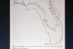
A map depicting the ancient shoreline of the Pamlico Sea, illustrating the extent of the shoreline when the sea level was approximately 25 feet higher than the current sea level.
Keywords
Weather, Sea level rise, Climate, Climate change
Extent
1 map
Physical Collection
Box
1
Folder
Binder 2
Language
English
Digital Date
2024
Media Type
Maps
Identifier
O19-02158
Recommended Citation
Hoffmeister, F. R., "Map, Shoreline of the Pamlico Sea When Sea Level Was 25 Feet Higher Than Present, 1974" (1974). Binder 02: Field Notes and Documents. 43.
https://digitalcommons.usf.edu/ogden2_notes/43
Rights Statement

