
Binder 18: Photographs and Images
Files
Download
Download Full Text (3.8 MB)
Preview
Creation Date
1995
Time Period
circa 1990s
Abstract
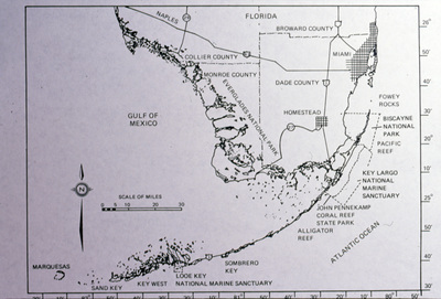
A map of South Florida specifically displaying Monroe County and the Florida Keys.
Alt Text
A map of the Florida Keys region, showing various counties and marine sanctuaries. The Gulf of Mexico is to the west and the Atlantic Ocean to the east.
Keywords
Maps, Counties
Extent
1 color photograph
Physical Collection
Box
6
Folder
Binder 18
Digital Date
2024
Media Type
Color photographs
Identifier
O19-02790
Recommended Citation
Ogden, John C., "Map of South Florida Displaying Monroe County and Florida Keys" (1995). Binder 18: Photographs and Images. Image 364.
https://digitalcommons.usf.edu/ogden18_images/364
Keywords
Maps, Counties
Rights Statement

