
Binder 18: Photographs and Images
Files
Download
Download Full Text (4.3 MB)
Preview
Creation Date
1995
Time Period
circa 1990s
Abstract
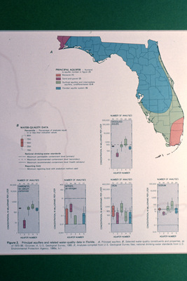
A map displaying the different aquifer systems in Florida and water quality data.
Alt Text
A map of Florida showing principal aquifers and water quality data with various graphs displaying the number of analyses and their results. The map uses different colors to represent various aquifer types and water quality conditions.
Keywords
Maps, Aquifers, Sites, Water quality
Extent
1 color photograph
Physical Collection
Box
6
Folder
Binder 18
Digital Date
2024
Media Type
Color photographs
Identifier
O19-02786
Recommended Citation
Ogden, John C., "Maps of Aquifer Systems and Water Quality Data in Florida" (1995). Binder 18: Photographs and Images. Image 360.
https://digitalcommons.usf.edu/ogden18_images/360
Keywords
Maps, Aquifers, Sites, Water quality
Rights Statement

