
Tampa Bay Area Map Collection
Files
Download Full Text (14.7 MB)
Preview
Creation Date
January 1898
Abstract
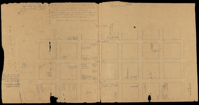
A hand-drawn plat map (also referred to as a cadastral map) for a section of downtown Tampa. Boundaries are the Hillsborough River to the west, Jefferson Street to the east, Whiting Street to the south, and Cass Street to the north.
Alt Text
Map drawn in pencil of a section of Downtown Tampa extending from the river to Jefferson St East to West and Cass to Madison St North to South. On each city block are notes relating to businesses that existed there in 1850's to 1890's.
Keywords
Cadastrals, Streets, Properties
Extent
1 map
Subject: geographic
Hillsborough County (Fla.); Tampa (Fla.)
Physical Collection
General Map Collection
Language
English
Media Type
Cadastral maps; Plats (Maps)
Note
The second half of this map is H61-00003.
Identifier
H61-00002
Recommended Citation
Unknown, "Property Map, Downtown Tampa, Florida, 1858-1898, Part 2" (1898). Tampa Bay Area Map Collection. Image 11.
https://digitalcommons.usf.edu/fl_maps_local/11
Keywords
Cadastrals, Streets, Properties
Rights Statement

