
Early Printed Map Collection
Alternative Title
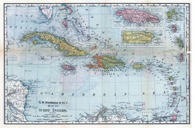
Map, A.D. Worthington and Company's Map of the West Indies, 1892
Files
Download
Download Full Text (7.7 MB)
Preview
Publisher
Rand, McNally and Company
Creation Date
January 1892
Abstract
A full-color map of the "West Indies." Includes the Bahamas, Cuba, Haiti, the Dominican Republic, Jamaica, Puerto Rico, the U.S. Virgin Islands and the island chain from Anguilla to Trinidad
Alt Text
Color political map of the West Indies with insets of Jamaica, Puerto Rico, and the Lesser Antilles.
Extent
1 map
Subject: geographic
West Indies, Caribbean Area
Physical Collection
Rare Map Collection
Call Number
Language
English
Media Type
Maps
Identifier
U16-0128-B
Recommended Citation
A.D. Worthington & Co., "Map, A.D. Worthington & Co.'s Map of the West Indies, 1892" (1892). Early Printed Map Collection. Image 24.
https://digitalcommons.usf.edu/fl_maps_early/24
Rights Statement

