
Early Printed Map Collection
Files
Download
Download Full Text (4.4 MB)
Preview
Publisher
S. Augustus Mitchell
Creation Date
1879
Abstract
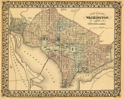
A road map of Washington, D.C. with different districts numbered. The streets stop at "Boundary Street" to the north, now Florida Avenue. Anacostia is marked as "Uniontown" on the map.
Alt Text
Plan of Washington DC showing streets, buildings, and roads. Buildings on and surrounding the National Mall area are labeled.
Extent
1 map
Subject: geographic
Washington (D.C.)
Physical Collection
Rare Map Collection
Call Number
Language
English
Media Type
Maps
Identifier
U16-0064
Recommended Citation
Gamble, William H., "Map, Plan of the City of Washington, the Capitol of the United States of America, 1879" (1879). Early Printed Map Collection. Image 5.
https://digitalcommons.usf.edu/fl_maps_early/5
Rights Statement

