
Early Printed Map Collection
Files
Download
Download Full Text (12.0 MB)
Preview
Creation Date
January 1897
Abstract
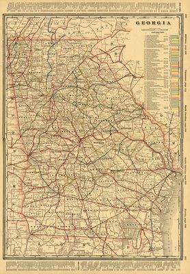
A map of railroad lines in Georgia from George F. Cram's 1897 Standard American Railway System Atlas. Included at the top is an index of maps. Included at the bottom is a continuation of an index of maps and an index of cities.
Alt Text
Map of Georgia showing existing railway lines. County boundaries are marked as well as cities.
Keywords
Railroads
Extent
1 map
Subject: geographic
Georgia
Physical Collection
Rare Map Collection
Language
English
Media Type
Maps
Identifier
U16-0042
Recommended Citation
Cram, George F., "Map, Railroad Lines in Georgia, 1897" (1897). Early Printed Map Collection. Image 2.
https://digitalcommons.usf.edu/fl_maps_early/2
Keywords
Railroads
Rights Statement

