
Early Printed Map Collection
Alternative Title
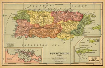
Map, Rand, McNally & Co.'s 11 x 14 New Map of Puerto Rico, 1898
Files
Download
Download Full Text (3.9 MB)
Preview
Publisher
Rand, McNally and Company
Creation Date
January 1898
Abstract
A full-color map of Puerto Rico. Includes an inset of San Juan and the Islands East of Puerto Rico including Vieques and Culebra.
Alt Text
Political map of Puerto Rico with inset maps of San Juan and the Islands East of Puerto Rico.
Extent
1 map
Subject: geographic
Puerto Rico; San Juan (P.R.); Vieques Island (P.R.); Culebra Island (P.R.)
Physical Collection
Rare Map Collection
Call Number
Language
English
Media Type
Maps
Identifier
U16-0063
Recommended Citation
Rand, McNally and Company, "Map, Puerto Rico, 1898" (1898). Early Printed Map Collection. Image 4.
https://digitalcommons.usf.edu/fl_maps_early/4
Rights Statement

