
Early Printed Map Collection
Alternative Title
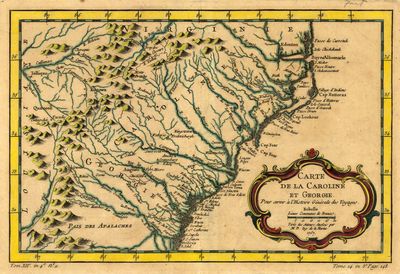
Map, Carolina and Georgia, 1757
Files
Download
Download Full Text (2.7 MB)
Preview
Creation Date
January 1757
Abstract
A map of North and South Carolina as well as part of Georgia with rivers and mountains marked.
Alt Text
Map of North and South Carolina, showing rivers and the Appalachian Mountain range. Latitude and Longitude are marked on the edges of the map.
Extent
1 map
Subject: geographic
North Carolina; South Carolina; Georgia
Physical Collection
Rare Map Collection
Language
French
Media Type
Maps
Identifier
U16-0105
Recommended Citation
Bellin, Jacques Nicolas, "Map, Carte de la Caroline et Georgie, 1757" (1757). Early Printed Map Collection. Image 19.
https://digitalcommons.usf.edu/fl_maps_early/19
Rights Statement

