
Early Printed Map Collection
Files
Download
Download Full Text (2.5 MB)
Preview
Publisher
Thomas & Andrews
Creation Date
1796
Abstract
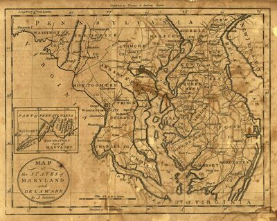
A map of Maryland and Delaware copied from Dennis Griffith's map of Maryland published in 1795. There is an inset for the western part of Maryland including Allegany County.
Alt Text
Map or Maryland and Delaware showing roads and settlements. An inset is shown for the western part of Marland.
Extent
1 map
Subject: geographic
Maryland; Delaware
Physical Collection
Rare Map Collection
Language
English
Media Type
Maps
Identifier
U16-0102
Recommended Citation
Denison, J., "Map, Map of the States of Maryland and Delaware, 1796" (1796). Early Printed Map Collection. Image 16.
https://digitalcommons.usf.edu/fl_maps_early/16
Rights Statement

