
Early Printed Map Collection
Alternative Title
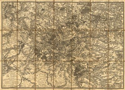
Map, Map of the Surroundings of Paris, July 1820
Files
Download
Download Full Text (18.2 MB)
Preview
Publisher
Chez Vicq
Creation Date
1820
Abstract
A map of Paris and its surrounding area with forests, roads, rivers, acqueducts, and postal routes marked.
Alt Text
Detailed map showing the environs of Paris. Roads, forests, rivers, and aqueducts are marked.
Extent
1 map
Subject: geographic
Paris (France)
Physical Collection
Rare Map Collection
Language
French
Media Type
Maps
Identifier
U16-0080
Recommended Citation
Picquet, Charles, "Map, Carte des Environs de Paris, July 1820" (1820). Early Printed Map Collection. Image 11.
https://digitalcommons.usf.edu/fl_maps_early/11
Rights Statement

