

Florida Maps Collection
Files
Download
Download Full Text (524 KB)
Preview
Creation Date
1804
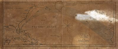
Abstract
Map of a portion of the North Atlantic, showing an early conception of the Gulf Stream, from Florida to Capo Blanco.
Keywords
Ocean currents
Extent
1 map
Subject: geographic
Atlantic Ocean; Gulf Stream
Physical Collection
Rare Map Collection
Language
English
Media Type
Map
Identifier
U15-0045
Recommended Citation
Gold, Joyce, "Map, Chart of the Supposed Course of the Florida Stream, 1804" (1804). Florida Maps Collection. Image 75.
https://digitalcommons.usf.edu/fl_maps_collection/75
Keywords
Ocean currents
Rights Statement

