

Florida Maps Collection
Files
Download
Download Full Text (524 KB)
Preview
Creation Date
1804
Abstract
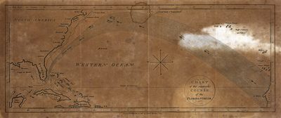
Map of a portion of the North Atlantic, showing an early conception of the Gulf Stream, from Florida to Capo Blanco.
Alt Text
Map of the Atlantic Ocean showing the supposed Florida Stream from Florida to Africa.
Keywords
Ocean currents
Scale
Scale not given
Extent
1 map
Subject: geographic
Atlantic Ocean; Gulf Stream
Physical Collection
Rare Map Collection
Language
English
Media Type
Map
Identifier
U15-0045
Recommended Citation
Gold, Joyce, "Map, Chart of the Supposed Course of the Florida Stream, 1804" (1804). Florida Maps Collection. Image 75.
https://digitalcommons.usf.edu/fl_maps_collection/75
Keywords
Ocean currents
Rights Statement

