

Florida Maps Collection
Files
Download Full Text (1.0 MB)
Preview
Publisher
John Luffman
Creation Date
1802
Abstract
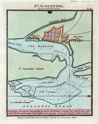
A map of St. Augustine which was the capital of East Florida. The map shows roads, Indigenous towns, the fort (San Marcos), inland waters, and depths. The caption at the bottom of the map reads "St. Augustine, the Capital of East Florida, N. America. The Harbour is shallow but secure. It was ceded during Mr. Pitt's administration by the English to the Spaniards."
Alt Text
Map of St. Augustine and the harbor area. Shown is the fort, the town, and Indian towns to the North and South.
Keywords
Harbors
Scale
Scale not given
Extent
1 map
Subject: geographic
St. Johns County (Fla.); St. Augustine (Fla.)
Language
English
Media Type
Map
Identifier
U15-9054
Recommended Citation
Luffman, John, "Map, St. Augustine Engraved for Luffman's Select Plans, 1802" (1802). Florida Maps Collection. Image 96.
https://digitalcommons.usf.edu/fl_maps_collection/96
Keywords
Harbors
Rights Statement

