

Florida Maps Collection
Files
Download
Download Full Text (1.3 MB)
Preview
Publisher
J. Cary
Creation Date
1806
Abstract
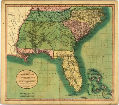
A map by John Cary with North Carolina, South Carolina, Georgia, Florida, West Florida, Tennessee, parts of the Bahamas, and a very small part of Kentucky and Virginia.
Alt Text
Map of the Southeast United States. Florida is shown separated as East and West Florida, and Georgia is extended west covering the area of Alabama.
Scale
4245120, Scale [ca. 1:4,245,120]
Extent
1 map
Subject: geographic
Bahamas; North Carolina; South Carolina; Kentucky; Tennessee; Georgia
Physical Collection
Rare Map Collection
Call Number
Language
English
Media Type
Map
Identifier
U15-0026
Recommended Citation
Cary, John, "Map, New Map of Parts of the United States of North America, 1806" (1806). Florida Maps Collection. Image 50.
https://digitalcommons.usf.edu/fl_maps_collection/50
Rights Statement

