

Florida Maps Collection
Files
Download Full Text (1.5 MB)
Preview
Publisher
Rand, McNally and Company
Creation Date
1898
Abstract
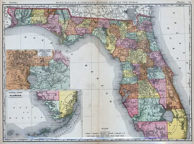
A detailed map of the state of Florida with an inset of the southern portion of Florida and an inset map showing parts of Lake, Orange, and Volusia counties. This map shows section township range (STR) except for the Everglades in (Miami-)Dade County which was not surveyed yet.
Alt Text
Map of Florida showing counties in varying colors. An inset map exists showing Orange, Volusia, and Lake Counties, and another showing the southern portion of Florida.
Scale
1203840, Scale [1:1,203,840]. 1 in. = 19 mi. 1 in. = 30 km.
Extent
1 map
Subject: geographic
Lake County (Fla.); Orange County (Fla.); Volusia County (Fla.)
Physical Collection
Rare Map Collection
Call Number
Language
English
Media Type
Map
Identifier
U15-0017
Recommended Citation
Rand, McNally and Company, "Map, Florida, 1898" (1898). Florida Maps Collection. Image 7.
https://digitalcommons.usf.edu/fl_maps_collection/7
Rights Statement

