

Florida Maps Collection
Files
Download Full Text (1.6 MB)
Preview
Publisher
Rand, McNally and Company
Creation Date
1895
Abstract
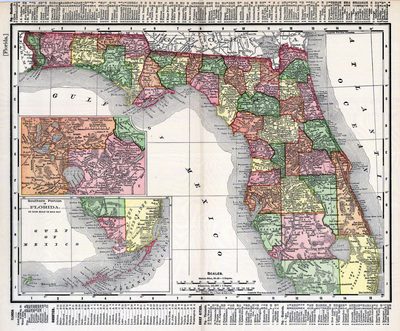
This map of Florida outlines the county boundaries and railroads connecting the major cities, current in 1895. The upper most inset map illustrates the intersection of Lake, Orange and Volusia counties on an enlarged scale. This inset map also conveys the relative proximity of the large lakes in the region. The lower right inset map illustrates the southern portion of Florida, more specifically the Florida Keys, which are a part of Monroe County.
Alt Text
Map of Florida showing counties in varying colors. An inset map exists showing Orange, Volusia, and Lake Counties, and another showing the southern portion of Florida.
Scale
2407680, Scale [1:2,407,680]
Extent
1 map
Subject: geographic
Lake County (Fla.); Orange County (Fla.); Volusia County (Fla.)
Physical Collection
Rare Map Collection
Call Number
Language
English
Media Type
Map
Identifier
U15-0088
Recommended Citation
Rand, McNally and Company, "Map, Florida, 1895" (1895). Florida Maps Collection. Image 21.
https://digitalcommons.usf.edu/fl_maps_collection/21
Rights Statement

