

Florida Maps Collection
Files
Download
Download Full Text (1.0 MB)
Preview
Publisher
William Faden
Creation Date
1777
Abstract
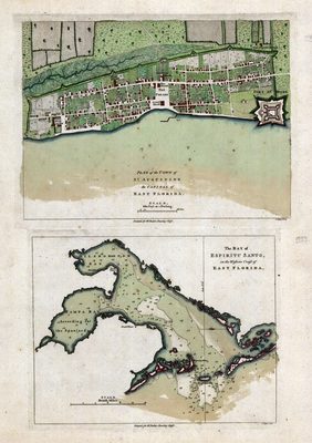
Two maps. One is the plan of St. Augustine and the other of the Tampa Bay area (called Espiritu Santo on this map).
Alt Text
Page showing 2 maps, the first being a plan of the city of St. Augustine in color. The second map is a nautical chart of the Tampa bay area, with the bay labeled Espiritu Santo.
Scale
4752, Scale [ca. 1:4,752].
Extent
1 map
Subject: geographic
St. Johns County (Fla.); Hillsborough County (Fla.); St. Augustine (Fla.), Tampa Bay (Fla.)
Physical Collection
Rare Map Collection
Language
English
Media Type
Map
Identifier
U15-0023
Recommended Citation
Jefferys, Thomas, "Map, Plan of the Town of St. Augustine; The Bay of Espiritu Santo on the Western Coast of East Florida 1777" (1777). Florida Maps Collection. Image 69.
https://digitalcommons.usf.edu/fl_maps_collection/69
Rights Statement

