

Florida Maps Collection
Files
Download Full Text (39.9 MB)
Preview
Publisher
Robert Sayer and John Bennett
Creation Date
1776
Abstract
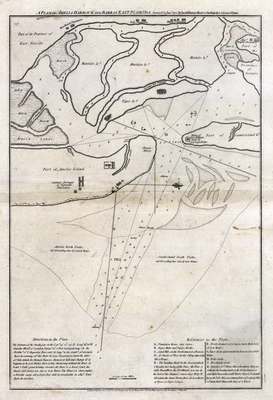
A map of Amelia Island area showing marshes, plantations, islands, water depths and more. Surveyed in 1775 by Jacob Blamey, Master of His Majesty's Schooner St. John. John Perceval, Second Earl of Egmont considered the Amelia River and her naturally deep harbor to be exceptional for water transportation.
Alt Text
A map of Amelia Island area in Northeast Florida showing marshes, plantations, islands, water depths and more.
Keywords
Nautical charts, Harbors
Scale
39000, Scale [ca. 1:39,000].
Extent
1 map
Subject: geographic
Nassau County (Fla.); Amelia Island (Fla.)
Language
English
Media Type
Map
Identifier
U15-9003
Recommended Citation
Blamey, Jacob, "Map, Plan of Amelia Harbour and Barr in East Florida, July 1776" (1776). Florida Maps Collection. Image 147.
https://digitalcommons.usf.edu/fl_maps_collection/147
Keywords
Nautical charts, Harbors
Rights Statement

