

Florida Maps Collection
Files
Download Full Text (1.3 MB)
Preview
Publisher
William Russell
Creation Date
1778
Abstract
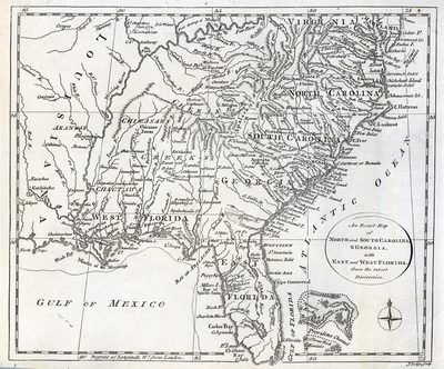
Map shows the southeastern colonies, from Virginia and Maryland south to Florida and west to Louisiana. Several indigenous nations are noted, including the Catawba, Cherokee, Maskoke (Creek), Choctaw, and Chickasaw.
Alt Text
Map of the Southeast United States with rivers and mountain ranges shown.
Keywords
Catawba, Cherokeee, Maskoke (Muskogee-Creek), Choctaw, Chickasaw
Scale
Scale not given
Extent
1 map
Subject: geographic
Virginia; North Carolina; South Carolina; Georgia; Louisiana; Bahamas
Language
English
Media Type
Map
Identifier
U15-9056
Recommended Citation
Lodge, John, "Map, Exact Map of North and South Carolina and Georgia, with East and West Florida from the Latest Discoveries, 1778" (1778). Florida Maps Collection. Image 97.
https://digitalcommons.usf.edu/fl_maps_collection/97
Keywords
Catawba, Cherokeee, Maskoke (Muskogee-Creek), Choctaw, Chickasaw
Rights Statement

