

Florida Maps Collection
Files
Download
Download Full Text (1.4 MB)
Preview
Creation Date
1823
Abstract
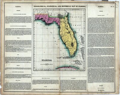
A map of Florida surrounding by explanatory text. Explanatory text includes sections: Situation, Boundaries, and Extent; Face of the Country, Soil, and Productions; Rivers; Bays; Climate; Civil Divisions and Population; Chief Towns; Islands; Government; Historical Sketch; and List of Governors
Alt Text
Map of Florida surrounded by information on Florida's history, topography, climate, towns, and government.
Scale
3801600, Scale [1:3,801,600. 1 in. to 60 miles].
Extent
1 map
Physical Collection
Touchton Map Collection
Holding Location
Tampa Bay History Center
Language
English
Media Type
Map
Identifier
U15-0016
Recommended Citation
Lucas, Fielding Jr., "Map, Geographical, Statistical, and Historical Map of Florida, 1823" (1823). Florida Maps Collection. Image 33.
https://digitalcommons.usf.edu/fl_maps_collection/33
Rights Statement

