

Florida Maps Collection
Alternative Title
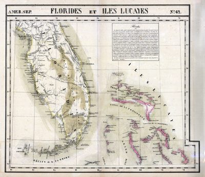
Map, Florida and Lucayan Islands, 1825
Files
Download
Download Full Text (1.2 MB)
Preview
Creation Date
1825
Abstract
A map showing early roads in Florida, the Indiana trail which traverses the peninsula, and annotations on the Everglades. The Lucayan Islands include the Bahamas and Turks and Caicos Islands.
Alt Text
Map of the peninsula of Florida and the Bahama's showing several trails across Florida.
Scale
Scale not given
Extent
1 map
Subject: geographic
Bahamas; Turks and Caicos Islands
Physical Collection
Rare Map Collection
Call Number
Language
French
Media Type
Map
Identifier
U15-0032
Recommended Citation
Vandermaelen, Philippe Marie, "Map, Florides et Iles Lucayes, 1825" (1825). Florida Maps Collection. Image 73.
https://digitalcommons.usf.edu/fl_maps_collection/73
Rights Statement

