

Florida Maps Collection
Files
Download
Download Full Text (104.5 MB)
Preview
Creation Date
1823
Time Period
circa 1823
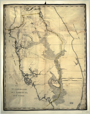
Abstract
A map of Florida between Micanopy in the north and Key Biscayne in the south. At lower left is probable reference to 1823 Map of Florida by Charles Vignoles.
Alt Text
A map of Florida between Micanopy in the north and Key Biscayne in the south showing land belonging to R.S. Hackley.
Keywords
Real property
Scale
525000, Scale [ca. 1:525,000]
Extent
1 map
Physical Collection
General Map Collection
Language
English
Media Type
Map
Identifier
U15-9028
Recommended Citation
Hackley, Richard S., "Map, Lands Belong to Richard S. Hackley in East Florida, circa 1823" (1823). Florida Maps Collection. Image 162.
https://digitalcommons.usf.edu/fl_maps_collection/162
Keywords
Real property
Rights Statement

