
USF Photograph Collection
Files
Download Full Text (1.7 MB)
Preview
Creation Date
1956
Abstract
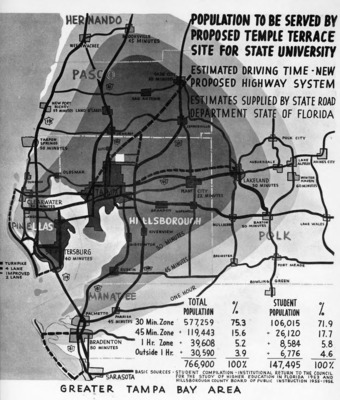
The Hillsborough Board of County Commissioners produced this map in 1956 showing the population in the greater Tampa Bay area and the large number of potential students that were within one hour's drive to what would become USF.
Alt Text
A map showing population zones and estimated driving times from a proposed site for a state university in the Greater Tampa Bay Area, Florida. The map includes various cities and towns with their respective driving times and population statistics.
Keywords
Maps
Extent
1 map
Subject: geographic
Hillsborough County (Fla.); Tampa (Fla.); Tampa Bay Region (Fla.)
Language
English
Media Type
Maps
Identifier
U10-00231
Recommended Citation
Board of County Commissioners, "Map Showing the Population that Will be Served by a New University in Tampa" (1956). USF Photograph Collection. Image 227.
https://digitalcommons.usf.edu/usf_photos/227
Keywords
Maps
Rights Statement

