

Dr. Garald Gordon Parker Collection - Images
Files
Download
Download Full Text (3.8 MB)
Preview
Creation Date
1950
Time Period
circa 1950s
Abstract
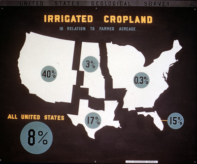
Pictograph representing irrigated cropland in relation to farmed acreage in the United States.
Alt Text
A map of the United States showing percentages of irrigated cropland relative to farmed acreage by state, with a national average highlighted. The title "Irrigated Cropland" and source "United States Geological Survey" are displayed at the top.
Keywords
Irrigation, Agriculture
Extent
1 pictograph
Physical Collection
Language
English
Media Type
Pictographs
Identifier
G16-00120
Recommended Citation
Parker, Garald Gordon, "Pictograph, Irrigated Cropland in Relation to Farmed Acreage" (1950). Dr. Garald Gordon Parker Collection - Images. Image 81.
https://digitalcommons.usf.edu/parker_photographs/81
Keywords
Irrigation, Agriculture
Rights Statement

