

Dr. Garald Gordon Parker Collection - Images
Files
Download
Download Full Text (3.9 MB)
Preview
Creation Date
1950
Time Period
circa 1950s
Abstract
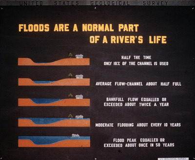
Diagram showing the standard water levels on a river over time and how often flooding, and what level of flooding, might happen.
Alt Text
A poster from the United States Geological Survey explaining different flood levels of a river, with illustrations showing varying water heights and usage percentages of the channel. The text describes the frequency of different types of flooding events.
Keywords
Water levels, Rivers, Floods
Extent
1 diagram
Physical Collection
Language
English
Media Type
Diagrams
Identifier
G16-00113
Recommended Citation
Parker, Garald Gordon, "Diagram, Flood are a Normal Part of a River's Life" (1950). Dr. Garald Gordon Parker Collection - Images. Image 74.
https://digitalcommons.usf.edu/parker_photographs/74
Keywords
Water levels, Rivers, Floods
Rights Statement

