

Dr. Garald Gordon Parker Collection - Images
Files
Download Full Text (5.8 MB)
Preview
Creation Date
5-1975
Abstract
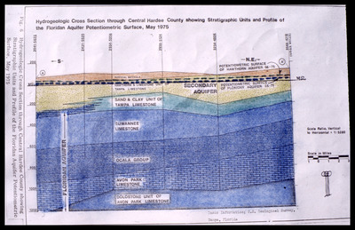
A diagram of hydrogeologic cross section through Central Hardee County, Florida showing stratigraphic units and profile of the Floridan Aquifer potentiometric surface for May 1975.
Alt Text
A detailed geological cross-section diagram showing various stratigraphic units and the Floridan Aquifer potentiometric surface from May 1975. The image includes labeled layers of rock formations, aquifers, and other geological features with a scale for reference.
Keywords
Floridan Aquifer, Aquifers, Potentiometry, Geology, Geological cross sections
Extent
1 diagram
Subject: geographic
Hardee County (Fla.)
Physical Collection
Language
English
Media Type
Diagrams
Identifier
G16-00598
Recommended Citation
Parker, Garald Gordon, "Diagram, Hydrogeologic Cross Section through Central Hardee County Showing Stratigraphic Units and Profile of the Floridan Aquifer Potentiometric Surface" (1975). Dr. Garald Gordon Parker Collection - Images. Image 516.
https://digitalcommons.usf.edu/parker_photographs/516
Keywords
Floridan Aquifer, Aquifers, Potentiometry, Geology, Geological cross sections
Rights Statement

