

Dr. Garald Gordon Parker Collection - Images
Files
Download Full Text (4.3 MB)
Preview
Creation Date
1970
Time Period
circa 1970-1987
Abstract
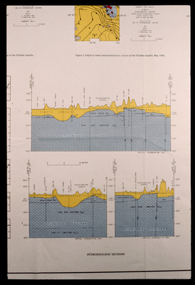
A set of diagrams of hydrogeologic sections. One is "Depth to water and potentiometric surface of the Floridan Aquifer, May 1968." The others are cross sections for Lake County between Marion County and Polk County; and Lake County between Sumter County and Orange County.
Alt Text
A scientific diagram showing hydrogeologic sections with various layers and measurements. The top section includes a map, while the bottom features detailed cross-sectional views of subsurface formations.
Keywords
Geology, Geologic cross sections, Hydrogeology
Extent
3 diagrams
Subject: geographic
Lake County (Fla.); Marion County (Fla.); Polk County (Fla.); Sumter County (Fla.); Orange County (Fla.)
Physical Collection
Language
English
Media Type
Diagrams
Identifier
G16-00511
Recommended Citation
Parker, Garald Gordon, "Diagrams, Hydrogeologic Sections" (1970). Dr. Garald Gordon Parker Collection - Images. Image 479.
https://digitalcommons.usf.edu/parker_photographs/479
Keywords
Geology, Geologic cross sections, Hydrogeology
Rights Statement

