

Dr. Garald Gordon Parker Collection - Images
Files
Download Full Text (4.8 MB)
Preview
Creation Date
8-20-1977
Abstract
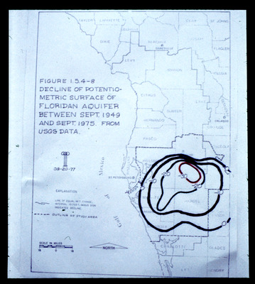
Map showing decline of potentiometric surface of Floridan Aquifer between September 1949 and September 1975. Also included on the map are the boundaries of the Southwest Florida Water Management District.
Alt Text
A map of Florida with annotations and a title describing the decline of the potentiometric surface of the Floridian aquifer between September 1949 and September 1975. The map includes various counties and geographical features, with lines indicating changes over time.
Keywords
Floridan Aquifer, Aquifers, Potentiometry, Southwest Florida Water Management District (Fla.)
Extent
1 map
Physical Collection
Language
English
Media Type
Maps
Identifier
G16-00449
Recommended Citation
Parker, Garald Gordon, "Map, Decline of Potentiometric Surface of Floridan Aquifer between September 1949 and September 1965 from USGS Data" (1977). Dr. Garald Gordon Parker Collection - Images. Image 409.
https://digitalcommons.usf.edu/parker_photographs/409
Keywords
Floridan Aquifer, Aquifers, Potentiometry, Southwest Florida Water Management District (Fla.)
Rights Statement

