

Dr. Garald Gordon Parker Collection - Images
Files
Download Full Text (3.6 MB)
Preview
Creation Date
5-19-1976
Abstract
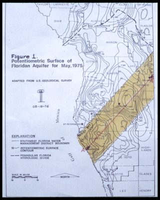
Map showing potentiometric surface of Floridan Aquifer for West-Central Florida for May 1975. Also included are the boundaries for the Southwest Florida Water Management District.
Alt Text
A map showing the potentiometric surface of the Floridan Aquifer as of May 1975, with various contour lines and labels indicating water levels and geographic features. The map includes an explanation key and a compass rose for orientation.
Keywords
Floridan Aquifer, Aquifers, Potentiometry, Southwest Florida Water Management District (Fla.)
Extent
1 map
Physical Collection
Language
English
Media Type
Maps
Identifier
G16-00444
Recommended Citation
Parker, Garald Gordon, "Map, Potentiometric Surface of Floridan Aquifer for May 1975" (1976). Dr. Garald Gordon Parker Collection - Images. Image 404.
https://digitalcommons.usf.edu/parker_photographs/404
Keywords
Floridan Aquifer, Aquifers, Potentiometry, Southwest Florida Water Management District (Fla.)
Rights Statement

