

Dr. Garald Gordon Parker Collection - Images
Files
Download
Download Full Text (3.7 MB)
Preview
Creation Date
3-29-1975
Abstract
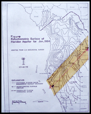
Map showing potentiometric surface of Floridan Aquifer for West-Central Florida for January 1964
Alt Text
A map showing the potentiometric surface of the Floridan Aquifer as of January 1964, with various contour lines and geographical features labeled. The map includes explanations for different boundaries and symbols used.
Keywords
Floridan Aquifer, Aquifers, Potentiometry
Extent
1 map
Physical Collection
Language
English
Media Type
Maps
Identifier
G16-00442
Recommended Citation
Parker, Garald Gordon, "Map, Potentiometric Surface of Floridan Aquifer for January 1964, Line A to A" (1975). Dr. Garald Gordon Parker Collection - Images. Image 402.
https://digitalcommons.usf.edu/parker_photographs/402
Keywords
Floridan Aquifer, Aquifers, Potentiometry
Rights Statement

