

Dr. Garald Gordon Parker Collection - Images
Files
Download Full Text (18.9 MB)
Preview
Publisher
United States. Department of the Interior
Creation Date
6-20-1979
Abstract
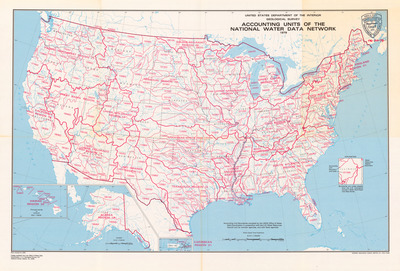
A map of the United States illustrating the accounting units of the national water data network. Legend includes accounting unit boundary and code, and water resources region boundary. Boundaries and codes for this map adapted from the U.S. Geological Survey's State Hydrologic Unit Map Series.
Alt Text
A detailed map of the United States showing the national water data network. The map includes state boundaries and some geographical features.
Keywords
Geological Survey (U.S.), Water resources map
Extent
1 map
Physical Collection
Box
10
Folder
9
Language
English
Media Type
Maps
Identifier
G16-00017
Recommended Citation
United States Department of the Interior, "Map, Accounting Units of the National Water Data Network" (1979). Dr. Garald Gordon Parker Collection - Images. Image 4.
https://digitalcommons.usf.edu/parker_photographs/4
Keywords
Geological Survey (U.S.), Water resources map
Rights Statement

