

Dr. Garald Gordon Parker Collection - Images
Files
Download
Download Full Text (6.9 MB)
Preview
Creation Date
7-14-1977
Abstract
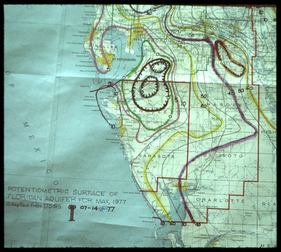
Map showing potentiometric surface of Floridan Aquifer for Southwest Florida for May 1977. The map is focused on Manatee County.
Alt Text
A detailed map showing the potentiometric surface of the Floridan Aquifer with contour lines and labeled regions. The map includes color-coded elevation data and geographic boundaries.
Keywords
Floridan Aquifer, Aquifers, Potentiometry
Extent
1 map
Subject: geographic
Manatee County (Fla.)
Physical Collection
Language
English
Media Type
Maps
Identifier
G16-00438
Recommended Citation
Parker, Garald Gordon, "Map, Potentiometric Surface of Floridan Aquifer for May 1977, Focus on Manatee County" (1977). Dr. Garald Gordon Parker Collection - Images. Image 399.
https://digitalcommons.usf.edu/parker_photographs/399
Keywords
Floridan Aquifer, Aquifers, Potentiometry
Rights Statement

