

Dr. Garald Gordon Parker Collection - Images
Files
Download Full Text (10.0 MB)
Preview
Creation Date
1-30-1976
Abstract
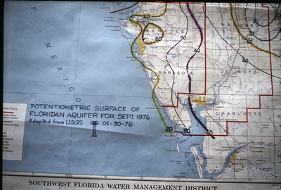
Map showing potentiometric surface of Floridan Aquifer in Southwest Florida for September 1976
Alt Text
Part of a map showing the potentiometric surface of the Floridan Aquifer as of September 1976, with various contour lines and labels indicating water levels. The map includes regions such as Sarasota and Charlotte, and is adapted from USGS data dated January 30, 1976.
Keywords
Floridan Aquifer, Aquifers, Potentiometry
Extent
1 map
Subject: geographic
Sarasota County (Fla.); De Soto County (Fla.)
Physical Collection
Language
English
Media Type
Maps
Identifier
G16-00353
Recommended Citation
Parker, Garald Gordon, "Map, Potentiometric Surface of Floridan Aquifer for September 1976, Sarasota and De Soto Counties" (1976). Dr. Garald Gordon Parker Collection - Images. Image 314.
https://digitalcommons.usf.edu/parker_photographs/314
Keywords
Floridan Aquifer, Aquifers, Potentiometry
Rights Statement

