

Dr. Garald Gordon Parker Collection - Images
Files
Download
Download Full Text (9.2 MB)
Preview
Creation Date
6-17-1977
Abstract
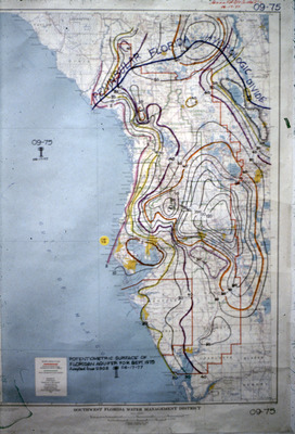
Map showing potentiometric surface of Floridan Aquifer in the Southwest Florida for September 1975.
Alt Text
A detailed topographic map of a coastal area with various contour lines and markings, dated September 1975. The map includes labels and color-coded lines indicating elevation changes and geographical features.
Keywords
Floridan Aquifer, Aquifers, Potentiometry
Extent
1 map
Physical Collection
Language
English
Media Type
Maps
Identifier
G16-00347
Recommended Citation
Parker, Garald Gordon, "Map, Potentiometric Surface of Floridan Aquifer for September 1975" (1977). Dr. Garald Gordon Parker Collection - Images. Image 308.
https://digitalcommons.usf.edu/parker_photographs/308
Keywords
Floridan Aquifer, Aquifers, Potentiometry
Rights Statement

