

Dr. Garald Gordon Parker Collection - Images
Files
Download Full Text (10.5 MB)
Preview
Creation Date
1970
Time Period
circa 1970-1987
Abstract
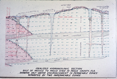
A diagram of geological layers from the Gulf of Mexico to the Pasco High in Pasco County, Florida.
Alt Text
A detailed geological cross-section diagram showing various layers of soil and rock formations, with annotations indicating water tables and zones. The illustration includes labels such as "salt-water encroachment" and different types of geological strata. The illustration is entitled "Idealized Hydrogeologic Section Gulf of Mexico to Pasco High in Pasco County, Florida, Showing Salt-Water Encroachment in Permeable Zones Separated by Two Impermeable Zones."
Keywords
Geology, Geologic cross sections, Hydrogeology, Saltwater encroachment
Extent
1 diagram
Subject: geographic
Pasco County (Fla.)
Physical Collection
Language
English
Media Type
Diagrams
Identifier
G16-00068
Recommended Citation
Parker, Garald Gordon, "Diagram, Idealized Hydrogeologic Section, Gulf of Mexico to Pasco High in Pasco County, Florida, Showing Salt-Water Encroachment in Permeable Zones Separated by Two Impermeable Zones" (1970). Dr. Garald Gordon Parker Collection - Images. Image 30.
https://digitalcommons.usf.edu/parker_photographs/30
Keywords
Geology, Geologic cross sections, Hydrogeology, Saltwater encroachment
Rights Statement

